Japan weather updates
News (1) to (5) / Reprinted from Central News Agency / Editor: Lu Yongxin / https://www.ntdtv.com/gb/2024/08/28/a103908891.html
News (1)
Typhoon Shanshan may cross all of Japan. The Meteorological Agency warns: Facing unprecedented storms
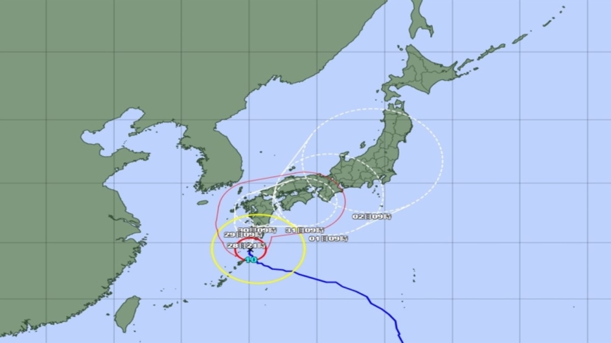
Image : The picture shows the potential prediction map of the path of Typhoon Shanshan. (Picture taken from the Japan Meteorological Agency jma.go.jp)
This year's No. 10 typhoon Shanshan continues to strengthen. The Japan Meteorological Agency predicts that the central pressure may drop to 925 hPa before landing, the "strongest level in history". This morning (28 August 2024) announced that special alerts will be issued for some areas. The Japanese government has also established a countermeasures headquarters to respond.
According to reports from Japanese media such as Nippon TV, Asahi Shimbun, Fuji News Network and NHK, the Japanese government established a "Special Disaster Countermeasures Headquarters" headed by Minister of Disaster Prevention Yoshifumi Matsumura this morning in accordance with the Basic Law on Disaster Countermeasures. This is the second time that the Japanese government has established a special disaster countermeasures headquarters due to a typhoon after Typhoon Nanmadol in 2022.
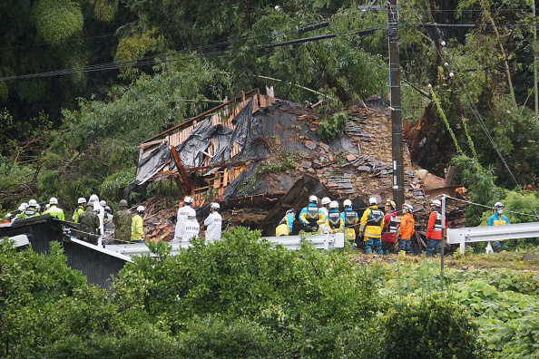
Image : The picture shows rescuers outside a house that suffered a landslide in Gamagori, Aichi Prefecture on August 28, 2024. On August 28, Japan suffered a landslide caused by heavy rain when Typhoon Shanshan arrived, causing a family of four to go missing. (STR/JIJI Press/AFP via Getty Images)
News (2)
The Japanese government responded urgently and Kishida issued three instructions
Prime Minister Fumio Kishida also issued three instructions to relevant ministries, including timely and correct provision of disaster prevention information, making full preparations for people's evacuation and assistance, and the government will do its best to respond to disasters once a disaster occurs.
The Meteorological Agency said at 7 am today that as Shanshan approaches southern Kyushu, various special alerts may be issued for Kagoshima Prefecture around noon, and a heavy rain special alert may also be issued for southern Kyushu including Miyazaki Prefecture.
The Meteorological Agency said that unprecedented storms and record-breaking rains are predicted, and "people must be on high alert" and evacuate during the day before the wind and rain intensify.
Once the Meteorological Agency issues a special alert for Shanshan this time, it will be the fourth time after 2014, 2016 and 2022. The first three times were issued for Miyakojima and Okinawa Island, Okinawa Island and Kagoshima Prefecture respectively.
News (3)
Shanshan's path becomes similar to Nanmadol in 2022
Shanshan's original path was thought to be similar to Typhoon Yanzi, which hit Kansai region hard in 2018. However, because the path is constantly revised, according to the latest typhoon path potential forecast map released by the Meteorological Agency, Shanshan's path has become similar to Typhoon Nanmadol No. 14 in 2022.
Nanmadol was called the "strongest level" typhoon in history by Japanese media that year, and the U.S. military also identified it as a "super typhoon". After landing in Kyushu, it brought record-breaking storms and heavy rains, causing the unfortunate deaths of 5 people and damage to more than 3,000 houses.
According to the information released by the Meteorological Agency at 10.45 am, Shanshan was located on the sea about 120 kilometers southwest of Yakushima, Japan at 10 am, moving slowly toward the northwest. The current central pressure has dropped to 935 hPa, the maximum wind speed near the center has increased to 50 metres per second, and the maximum instantaneous wind speed has also increased to 70 metres per second. It is classified as a "very strong typhoon" by the Meteorological Agency.
Not only that, it is currently predicted that Shanshan's central pressure will further drop to 925 hPa at 9 pm today, the maximum wind speed near the center will remain at 50 metres per second, and the maximum instantaneous wind speed will be 70 metres per second.
At 9 am on 29 August 2024, before it could make landfall, Shanshan maintained a very strong typhoon force with a central pressure of 925 hPa, a maximum wind speed of 50 m/s near the center, and a maximum instantaneous wind speed of 70 m/s.
According to the statistics released by the Meteorological Agency from 1951 to 2023, the top five typhoons with the lowest central pressure when making landfall were 925 hPa, 929 hPa, 930 hPa, 935 hPa, and 940 hPa, respectively.
Among them, the 925 hPa typhoon occurred on 16 September 1961, and it is the only one so far.
News (4)
Shanshan is heading northward, and the impact range and time are extended
According to the latest typhoon path potential forecast map released by the Meteorological Agency, due to Shanshan's very slow movement speed, the time and range of its impact on most areas of Japan from south to north will be extended and expanded.
Shanshan may turn to the northeast on 29 August 2024, land in Kyushu before the morning of the 30th, land in Shikoku twice on the 31st, and land in Honshu three times before the morning of 1 September 2024, and then go north across the Japanese archipelago. The centre will be located in the northern part of Kanto in the morning of 2 September 2024.
News (5)
High water temperature and no wind make the typhoon easy to strengthen
Why did Shanshan strengthen so quickly, even stronger than the Meteorological Agency's forecast a few days ago? Typhoon expert, Kyoto University Disaster Prevention Research Institute and Yokohama National University Associate Professor Ito Kosuke said that this is because the sea surface temperature in the sea area where Shanshan passes is as high as the water temperature at a slightly deeper depth.
Although this is a period of high sea surface temperature, this year it is about 1 to 2 degrees Celsius higher than in previous years and the water temperature at a depth of about 50 metres was also nearly 30 degrees when Shanshan passed.
In addition, there was no wind blowing over Shanshan that would destroy the typhoon structure, and it was far away from the westerly belt, the Qinghai-Tibet High Pressure and the Pacific High Pressure. Therefore, it can be said that high sea temperature and no wind provide an environment where typhoons can easily strengthen.
Ito Kosuke said that if Shanshan continues to strengthen, its intensity may be comparable to the "strongest level in history" in terms of the typhoons predicted to land in Kyushu.
News (6) to (9) / Reprinted from Central News Agency / Editor: Lu Yongxin / https://www.ntdtv.com/gb/2024/08/30/a103909411.html
News (6)
Typhoon Shanshan hits Japan, heavy rain breaks record in 2 places, causing 4 deaths and nearly 100 injuries
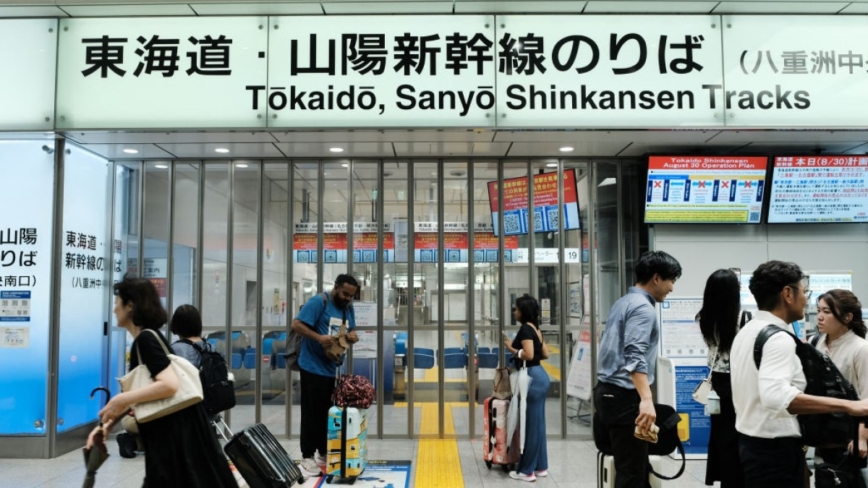
Image : On 30 August 2024, heavy rain caused the JR Tokyo Station train to stop running in Tokyo, and the ticket gate of the Tokaido Shinkansen platform was closed. (Kazuhiro Nogi/AFP via Getty Images)
Before landing in Japan, this year's No. 10 typhoon Shanshan, which was considered to be close to the "strongest level in history", has caused hundreds of deaths and injuries in Kyushu and other places. As its power continues to weaken, the Japan Meteorological Agency predicts that Shanshan may turn into a tropical depression before the morning of 1 September 2024.
News (7)
Record-breaking heavy rains hit Kanto and Tokai
NHK compiled Shanshan’s disaster report by itself. As of 10 am. today (30 August 2024), if the landslide in Aichi Prefecture on August 27 caused by heavy rains severely damaged residential buildings and caused 3 deaths and 2 injuries, the Shanshan-related disasters have caused 4 deaths, 96 injuries and 1 missing.
Heavy rains began to fall in the southern part of Kanto last night. The accumulated rainfall in Odawara City, Kanagawa Prefecture, reached 314.5 mm in the 24 hours up to 8:50 a.m. today, which is 1.8 times the rainfall in August in previous years.
Looking at Shizuoka City in the Tokai region, the accumulated rainfall in the 72 hours up to 5:40 a.m. today was as high as 515.5 mm, which is 2.7 times the rainfall in August in previous years.
Record-breaking heavy rains fell in Kanto and Tokai, and flooding disasters were reported frequently in some areas.
According to the police and fire department in charge of Hiratsuka City, Kanagawa Prefecture, due to the heavy rain, flooding of urban roads and waterlogging of houses have occurred, and vehicles have been stranded on the road.
From the photos taken by the public, it can be seen that a parking lot near the house of Hiratsuka citizens was severely flooded, and about 20 cars were flooded, with the water depth reaching about half the height of the car door.

Image : On 30 August 2024, at Beppu Station in Beppu City, Oita Prefecture, a woman looked at a souvenir shop that was closed due to the typhoon. (Yuichi Yamazaki/AFP via Getty Images)
The Tokaido Shinkansen suddenly stopped running, and the train hotel provided overnight accommodation for passengers
The sudden heavy rain also disrupted land and air transportation in various parts of Japan. JR Central Company said that although the Tokaido Shinkansen between Tokyo and Osaka has been suspended from the first train today, the section between Nagoya Station and Shin-Osaka Station has resumed operation since about 10 am; as for the section between Tokyo Station and Nagoya Station, it will remain suspended all day.
The Kyushu Shinkansen is completely suspended today; although the West Kyushu Shinkansen is also completely suspended from the first train today, it will be reduced and resumed as long as it can be confirmed to be safe.
The Sanyo Shinkansen section between Hiroshima Station and Hakata Station will be suspended from the first train today, and the Shin-Osaka Station to Hiroshima Station section will be greatly reduced, and it will not be able to directly operate with the Tokaido Shinkansen. The Shin-Osaka Station to Hakata Station section may continue to be suspended tomorrow.
As for the Hokuriku Shinkansen, due to the suspension of the Tokaido Shinkansen, many passengers switched to the Hokuriku Shinkansen, so JR East will add a temporary extra train from Tokyo Station to Tsuruga Station this afternoon.
The Tokaido Shinkansen was affected by heavy rain and typhoons last night, and all trains between Tokyo Station and Shin-Osaka Station were cancelled. Considering that passengers who cannot reach their destination may have nowhere to stay overnight, a "train hotel" was specially provided from last night to this morning for passengers to stay overnight on the train, with a total of about 700 people using it.
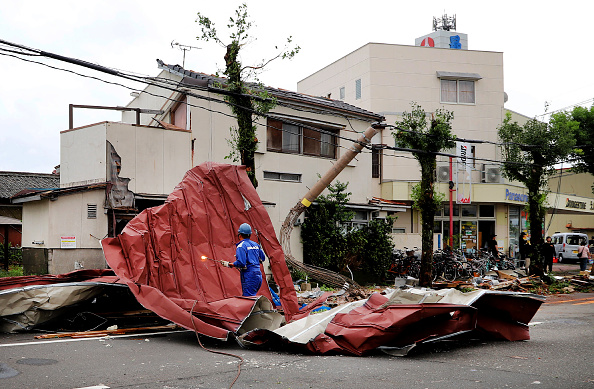
Image : A worker clears debris from strong winds caused by a typhoon in Miyazaki, August 29, 2024. (STR/JIJI Press/AFP via Getty Images)
News (8)
Japan Airlines and All Nippon Airways cancel 633 flights
In terms of air traffic, Japan Airlines canceled a total of 287 domestic flights today; All Nippon Airways also canceled 346 domestic flights.
As for tomorrow's domestic flights, Japan Airlines has decided to cancel 9 flights and All Nippon Airways has decided to cancel 33 flights.
In addition, airlines including Jetstar Japan, Skymark Airlines and Solaseed Air have also canceled some flights.
News (9)
Shanshan is moving slowly towards Shikoku
The information released by the Meteorological Agency at 10:45 this morning shows that Shanshan was near Kunisaki City, Japan at 10 a.m., moving northeast at a slow speed of 10 kilometers per hour. Its intensity has weakened significantly, with the central pressure rising to 994 hPa, the maximum wind speed near the center weakening to 20 meters per second, and the maximum instantaneous wind speed also weakening to 30 meters per second.
The Meteorological Agency predicts that Shanshan will further weaken to a tropical depression before 9 am on 1 September 2024, and will be located near Tenri City, Nara Prefecture.
According to the latest typhoon path potential forecast map, Shanshan will land in Shikoku today, and the centre will be located in Kochi Prefecture at 9 pm. Then it will continue to move slowly eastward, go out to sea again at 9 am on 31 August, and then turn northeastward towards Wakayama Prefecture.


No comments:
Post a Comment