Research, editing : Gan Yung Chyan, KUCINTA SETIA
News on Nature
3 typhoons together? Typhoon Suli is expected to form today and the weather will be extremely unstable from Friday to next Tuesday
Editor : Li Xinjie / https://news.ltn.com.tw/news/life/breakingnews/4802170?utm_source=life&utm_medium=OFFICIAL&utm_campaign=WEBPUSH&utm_content=20240917
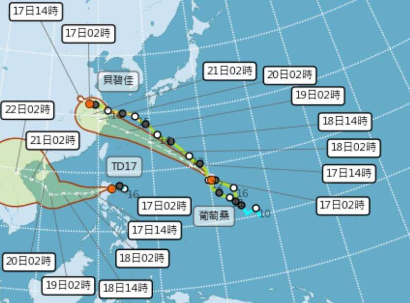
Image : The forecast path of Typhoon Suli from the Philippines as of 9.30 am, 17 September 2024 (Japan Metereological Agency). The path has left the east coast of Thailand as of 4 pm, 17 September 2024.
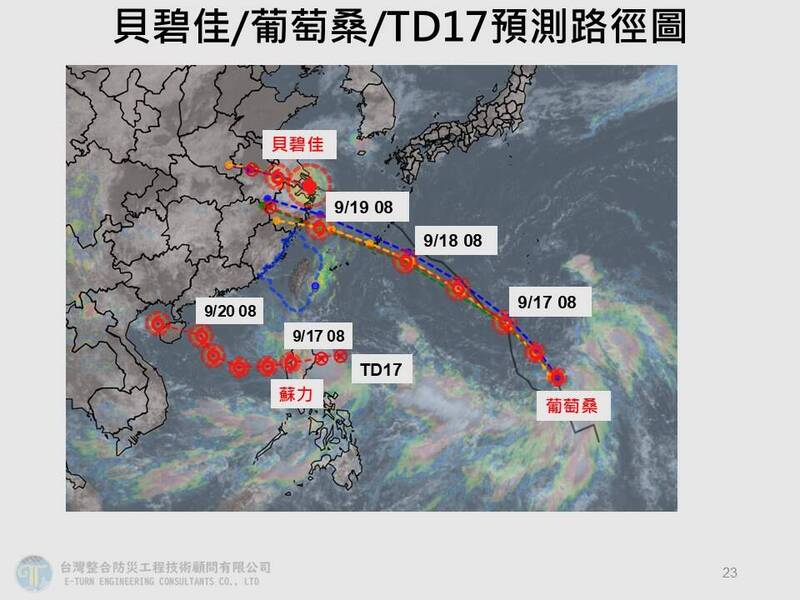
Image : At present, in addition to Typhoon Bebinca and Typhoon Putosang, the tropical depression in the eastern Philippines is expected to develop into Typhoon Suli today. However, Typhoon Bebinca, which has already made landfall in China, is expected to be destroyed today after its structure was obviously damaged. It will weaken into a tropical depression, and it remains to be seen whether there will be three coexistences at the same time. (Picture taken from Jia Xingxing’s Facebook)
Tropical systems have been active recently. In addition to Typhoon Bebika and Typhoon Putosang, the tropical depression in the eastern Philippines is expected to develop into Typhoon Suli on 17 September 2024. However, Typhoon Bebinca has already made landfall in China. After the structure was obviously damaged, it is expected to weaken into a tropical depression today. It remains to be seen whether there will be three typhoons coexisting at the same time. However, under the influence of the typhoon connecting into a large low-pressure belt, the weather is expected to remain extremely unstable from Friday to next Tuesday (20 to 24 September 2024), and "larger tropical disturbances" are expected to follow.
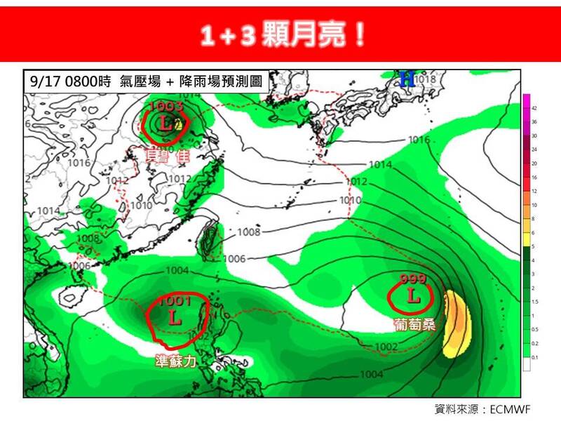
Lin De'en, a doctor of atmospheric sciences at National Taiwan University, posted on Facebook "Teacher Lin Weather Station" that in addition to the Mid-Autumn Festival, there are three other moons today, namely Typhoon Bebinca, Typhoon Putosang and the confirmed Typhoon Suli. Among them, Typhoon Bebinca made landfall on mainland China and its structure was obviously damaged. It is expected to weaken into a tropical depression today.
The "Teacher Lin Weather Station" pointed out that Typhoon Putosang continues to turn northwest and move northwest. It is expected to be closest to Taiwan on the 19th and will pass off the northern coast of Taiwan. Its intensity can only be maintained as a mild typhoon. The tropical depression is expected to develop into Typhoon Suli today and continue to move towards the South China Sea.
"Teacher Lin Weather Station" stated that judging from the current situation, these three moons are not interested in Taiwan. They not only passed by, but also missed them. However, according to the latest model simulation in the United States this morning, there is another tropical disturbance larger than these three moons around the 20th, approaching Taiwan. However, due to the large atmospheric environment variables and high uncertainty, continuous tracking and monitoring are still required.
Wu Derong, an adjunct associate professor of the Department of Atmosphere at Central University, wrote in the column "Sanli Quasi-Meteorology·The Big Brother Lets the Secret Out" today, pointing out that the No. 14 light station "Putosang" is heading northwest and west towards Ryukyu, and its predicted path is slightly southerly than "Bebinca". Light station No. 14 "Bebinca" is moving northwest to west and is expected to weaken into a tropical depression today.
Wu Derong pointed out that another tropical depression is expected to develop into the No. 15 light station "Suli" today after passing through Luzon Island and entering the South China Sea. It is predicted to turn westward and northwestward, gradually moving away. Wu Derong believes that the three platforms may not exist at the same time. He also reminded that although the current forecast data shows that the probability of direct invasion of Taiwan by these tropical systems is low, the models of various countries are still adjusting and should continue to be observed.
Wu Derong mentioned that today (Mid-Autumn Festival) there is a lot of moisture on the east side of Taiwan, and there are clouds in Greater Taipei and the eastern half, with the chance of occasional short-lived rain. The western half is cloudy and sunny, with occasional short-lived showers in the mountainous areas in the afternoon. It's still hot during the day, with the high temperature in the north reaching 37 degrees. As for the chance of local short-lived rain in the northern and eastern half tomorrow and the day after tomorrow, there is a chance of local showers or thunderstorms in the afternoon near the mountainous areas in the western half. From Friday to next Monday, water vapour in the south will move northward, making the atmosphere very unstable. On Friday and Saturday, there will be local showers or thunderstorms in southern Taiwan, and there is a chance of severe thunderstorms in the western half of the afternoon. Beware of lightning strikes, strong winds, and sudden heavy rainfall.
Jia Xingxing, director of Taiwan Integrated Disaster Prevention Engineering Technology Consulting Company, also pointed out that the 98W tropical disturbance located near Luzon Island in the Philippines is expected to enter the South China Sea today before it has the chance to develop into Typhoon Suli. Typhoon Putosang is expected to have a high probability of moving towards the Ryukyu Islands. The subsequent development and movement trends of these two typhoons require continued attention.
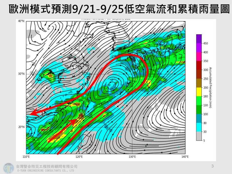
Jia Xingxing also reminded that although no typhoon is currently forecast to hit Taiwan, the two Taiwan stations are connected into a large low-pressure belt, causing Taiwan's weather to be extremely unstable. It is expected that the weather will be extremely unstable due to the influence of a large low-pressure belt from the 20th to the 24th. . There is a greater chance of showers or thunderstorms in some areas in the afternoon, especially in the western half and south of Tainan. By next Wednesday (25 September), there are still likely to be local brief showers in the afternoon north of Kaohsiung and east of Yihua.

Image : Tropical systems have been active recently. In addition to Typhoon Bebinca and Typhoon Putosang, the tropical depression in the eastern Philippines is expected to develop into Typhoon Suli today. (Picture taken from Meteorological Administration)
Image : "Teacher Lin Weather Station" issued an article stating that in addition to the Mid-Autumn Festival, there are three other moons today, namely Typhoon Bebinca, Typhoon Putosang and Typhoon Suli. Among them, Typhoon Bebinca made landfall on mainland China and its structure was obviously damaged. It is expected to weaken into a tropical depression today. (Picture taken from Facebook)

Image : Meteorological experts predict that under the influence of the typhoon connecting into a large low-pressure belt, the weather is expected to remain extremely unstable from Friday to next Tuesday (20 to 24 September), and "larger tropical disturbances" are expected to follow. (Picture taken from Jia Xingxing’s Facebook)
See also: Thailand weather forecast (16-22 September 2024), https://www.tmd.go.th/en/forecast/sevenday


No comments:
Post a Comment